Eastern Hemisphere
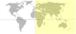
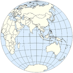
The Eastern Hemisphere, also Eastern hemisphere[1] or eastern hemisphere,[2] is a geographical term for the half of the Earth that is east of the Prime Meridian (which crosses Greenwich, England, United Kingdom) and west of 180° longitude.[3] It is also used to refer to Europe, Asia, Africa, and Australasia, vis-à-vis the Western Hemisphere, which includes the Americas. In addition, it may be used in a cultural or geopolitical sense as a synonym for 'Old World'.
The line demarcating the eastern and western hemispheres is an arbitrary convention, unlike the equator (an imaginary line encircling the Earth, equidistant from its poles) which divides the northern and southern hemispheres. The Prime Meridian at 0° longitude and the International Date Line, around 180° longitude are the conventionally accepted boundaries, since they divide eastern longitudes from western longitudes. Using this demarcation puts portions of western Europe, Africa and eastern Russia in the western hemisphere, thereby diluting its usefulness for cartography, as well as for geopolitical constructs, since all of Eurasia and Africa are typically included in the eastern hemisphere. Consequently, the meridians of 20°W and the diametrically opposed 160°E are often used,[4][5] which includes all of the European and African mainlands, but also includes a small portion of northeast Greenland (typically reckoned as part of North America) and excludes more of eastern Russia and Oceania (e.g., New Zealand).
The two major regions of Antarctica are named after their positions mainly within a single hemisphere; East Antarctica is named after the Eastern Hemisphere.
The mainland of the Eastern Hemisphere is larger than that of the Western Hemisphere (Americas) and have a wide variety of habitats.
References
- ↑ Oxford Dictionary of English, 2nd ed., rev. 2006. London, UK: Oxford University Press, p. 548.
- ↑ Merriam Webster's Online Dictionary (based olpln Collegiate vol., 11th ed.) 2006. Springfield, MA: Merriam-Webster, Inc.
- ↑ Latitude and Longitude at britannica.com, accessed 2008-05-24
- ↑ Olson, Judy M. "Projecting the hemisphere", ch. 4 from Matching the map projection to the need; Robinson, Arthur H. & Snyder, John P., eds. 1997. Bethesda, MD: Cartography and Geographic Information Society, American Congress on Surveying and Mapping.
- ↑ "Eastern Hemisphere". Merriam-Webster's Geographical Dictionary, 3rd ed. 2001. Springfield, MA: Merriam-Webster, Inc., p. 340.
|
|||||